New Gear
Harvesting
New Gear
Building Resource Roads
The construction of resource roads that pass through wetlands (such as fens, bogs, and swamps) can create numerous environmental and operational challenges for road managers. In addition, the impact of these resource roads on the many ecological functions of wetlands is of increasing concern to Canada’s resource-based industries and governments.
Wetlands provide many ecological functions that need to be maintained, such as water and carbon storage, filtering of precipitation during groundwater recharge, maintenance of downstream flows, support for plant communities, and wildlife habitat. When a resource road is built through a wetland, the wetland’s hydrologic functions may be compromised, with various negative outcomes.
There are many planning, construction and maintenance challenges associated with resource roads in wetland environments. Inadequate bearing capacity for the road sub-base and the installation of adequate drainage and water-crossing structures are common challenges. If adequate bearing capacity cannot be obtained by means of appropriate engineering to sustain the anticipated level of vehicle traffic, the road may not be usable. Roads that cross wetlands such as peatlands, where the soil continuously sinks or settles, may require ongoing maintenance and as a result, may not be cost-effective or may have seasonally restricted use. Drainage structures that underperform due to the lack of adequate bearing capacity or due to sinking or settling of the road may also need to be replaced.
Knowledge gaps
There remains considerable uncertainty regarding the impacts of resource roads on wetland processes and ecological values. There also remain many questions regarding the most effective planning, construction, and maintenance methods that can be implemented to reduce the impacts of resource roads on wetlands. Some of the key knowledge gaps include:
- How to reduce the environmental impact of resource roads on wetlands through improved planning.
- How to improve the soil’s bearing capacity and the suitability of the foundation for resource roads and water crossings.
- Developing suitable documentation (such as field guides) for resource road construction and maintenance in wetlands.
- Methods of completely assessing the effectiveness of recommended operational practices on the performance of resource roads and water crossings.
- Understanding of the long-term cumulative impacts of resource roads on wetland values (e.g., wetland processes, wildlife, carbon sequestration).
Mitigating the impact of resource roads on wetlands
Planning tools can be used to build resource roads in more favourable locations that will minimize the impacts to wetlands. For example, within the landscape of the boreal plains, it is difficult to entirely avoid crossing wetlands, so where and how often to cross a wetland is a significant planning constraint. The use of aerial photographs can aid in road location planning, and so can the use of remote-sensing tools such as LiDAR. By combining LiDAR-derived digital elevation maps with additional mapping tools (e.g., to calculate the depth to the water table or for automated wetland identification), a cost-effective and accurate tool can be made available to planners. Such tools can reveal features of the surface water, sensitive aquatic habitats, and the connectivity of habitats and other features of the landscape, thereby permitting appropriate choices of road locations, crossing structures and construction techniques.
A resource road built to cross a wetland at the narrowest location would seem to expose the smallest proportion of the wetland complex to adverse impacts. However, if the narrow area expands into a wider area downstream of the road, and if the road adversely affects the hydrologic regime of that wider area, the impact would be much greater than expected from the small size of the wetland crossing. In such cases, it may be better to cross a wider part of the wetland that will sustain less severe impacts. Wetland bank (edge) stability must also be assessed during planning because it will have significant impacts on where the road should enter the wetland. The concept of “island-hopping,” in which the road is positioned to take advantage of small stable areas (islands), may also prove beneficial during location planning.
Installation of effective drainage structures
Culverts: If culverts are being used to maintain flows of water through a wetland, they must be placed in locations that will allow the water to flow freely to downstream locations. Because wetlands can have very slow rates of water movement (as little as 10 centimetres per day), any blockage of this movement can seriously damage downstream hydrology. A section of road built with a single culvert placed along a wetland crossing may not be adequate because such slow-moving systems require unhindered passage of water. Numerous culverts may need to be installed along the road where it passes through the wetland. Because flows and water levels tend to increase during the wet season and decrease during the dry season, culverts may be needed at various heights to account for seasonal variations in the depth of the water.
Aggregate mattresses: Causeways or approaches can be built from angular pieces of large aggregate, which allow water to pass through the spaces between pieces. Careful attention to the management of fine soil particles is required to prevent these particles from filling the voids within the aggregate and interfering with water movement. A geotextile or other technique may be required to separate the road base from the underlying large angular aggregate to help prevent fine soil particles from migrating into the voids. As well, due to the slow movement of the water through the spaces in the causeway fine particles suspended in the flowing water are likely to fall out of suspension, so the design must include an upstream settling and deposition area and managers must plan to periodically remove the accumulated sediments. One of the main concerns with this method of wetland crossing is that there may be insufficient bearing capacity required to keep the large aggregates from sinking into the wetland. Geotextiles, geogrids, and other tools may be required to prevent or retard sinking.
Corduroy: Wetlands with low bearing capacity have traditionally been crossed using a “corduroy” surface created by laying numerous logs parallel to one another and perpendicular to the direction of travel. There are various techniques for building corduroy crossings, such as alternating the tops and butts of the logs. Some road builders will also add tops and slash (i.e., brush mats) on top of the logs for added strength. The logs allow water to flow between them, possibly eliminating the need for any culverts or drainage structures. These corduroy roads tend to settle over time and periodically require additional material to raise the road back up to the design grade.
Field trials
The ability of culverts to function properly and to provide the desired drainage across a road is of continued concern. The poor bearing capacity often associated with wetland features can challenge road design. It also requires the construction of suitable culvert foundations that offer long-term performance and the desired drainage.
Field trials in Saskatchewan and Manitoba were conducted to install drainage structures aimed at matching the hydrologic requirements of the wetland with the chosen structure / technique. FPInnovations brings technical and engineering expertise to a multi-partner project, funded in part by the Sustainable Forest Initiative (SFI), titled “Applying Expert Knowledge and Research Results in the Development of Best Practices for Forestry Road Design and Construction Around Wetlands.” The working group consists of Ducks Unlimited Canada, Louisiana Pacific Canada Ltd., Weyerhaeuser Company Limited and FPInnovations.
FPInnovations is a key partner in an Atlantic Canada project, also funded in part by SFI, titled “Mitigating Impacts of Road Construction in Forested Wetlands: Best Management Practices for the Forest Industry,” which was launched in May 2011.
This is a multi-partner project that includes governments (Nova Scotia Department of Environment, New Brunswick Department of Environment, Nova Scotia Department of Natural Resources), industry (J.D. Irving Limited, Resolute Forest Products), universities (Dalhousie University and the University of New Brunswick) and Ducks Unlimited Canada.
Saskatchewan
Working with Weyerhaeuser in Hudson Bay, Sask. an existing road crossing a wetland (shrub swamp) was excavated and a log bundle was installed to allow drainage through the road. The log bundle was chosen as an alternative to a traditional culvert. The crossing was constructed two tree-length logs high, approximately three metres wide and made from felled hardwoods onsite. Geotextile was used as a separation layer between the top of the bundle and the road fill material. The road was built back to grade within the same day (approximately five hours total) and water was observed flowing out from the log bundle on the downstream side.
Manitoba
In Swan River, Man., a field trial was held with Spruce Products Ltd. where new road construction was crossing a wetland (shrub swamp); a combination of softwood corduroy and culverts were used to allow drainage through the road. The main crossing was approximately 30 metres wide and was constructed of short (approximately 4.9 metres) logs laid end to end with a 300 millimetres plastic culvert positioned near the centre. Two layers of geotextile were used as a separation layer along the bottom and top of the structure. The road was built to grade and seepage was observed flowing from the logs on the downstream side. This trial site is expected to be monitored over time to help assess performance of hydrologic connectivity.
Ontario
FPInnovations, in partnership with EACOM, established a study site in northern Ontario where the impacts of two different culvert foundation methods will be assessed. The new road construction at this site was through a 200-metre wetland with a deep (six-metre) organic layer. Drainage was required to be provided across the road through the use of four 450-millimetre HDPE pipes. The deep organic soils, and their associated poor bearing capacity, was a particular challenge and innovative and cost-effective culvert foundations techniques were required. It was known that in other areas of Canada the use of geo-grid has been attempted as a means to provide support to the culvert. “Since the geo-grid was to be used as a road base, it would be installed directly under two of the pipes, with the remaining pipes installed on the forest floor with no provisions for an improved foundation.” It is believed that the geo-grid could act as a type of hammock, supporting the culvert and preventing sinkage due to the live load of passing vehicles and the load of the road fill material. In addition, a geotextile was placed under the geo-grid as this was the standard practice for the operations at this site.
The study site was established in November 2011 and the road and culvert locations have been surveyed and their performance will be measured again in 2012.
Atlantic Canada
The first phase of this project, which was to establish the initial field studies, was completed in 2011. This work was designed and led by Dalhousie University M.Sc. candidate Kent Mader who worked to establish six study sites in New Brunswick and Nova Scotia. At each of the study sites the road construction techniques were monitored and piezometers were installed to measure the short-term changes in the water table due to the road construction activities.
At each study site plastic pipes were installed to facilitate cross-drainage, the pipes were buried 50% to provide subsurface flows. Further study sites will be established in 2012, and at these sites the cross-drain pipe will be installed to full-depth, completely burying the pipe. Evaluations will be made of the ability of the cross-drain pipes to provide for subsurface flows at 50% and 100% burial. Soil surveys and wetland delineation will also be conducted with the objective that changes in the natural water balance at the study sites can be determined and road construction BMPs can be developed to mitigate these changes in the forested wetlands.
With research projects still ongoing across much of Canada, data is still being collected to help understand the best practices for building resource roads in sensitive areas. This research will help to ensure that the environment is not compromised by the need to remove wood from designated areas, and will provide better access for forest operations in areas that can be difficult to reach.
For more information about the studies being done by FPInnovations on best practices for building roads in sensitive areas, visit www.feric.caroads_wetlands_en.
August 13, 2012 By Mark Partington and Clayton Gillies FPInnovations
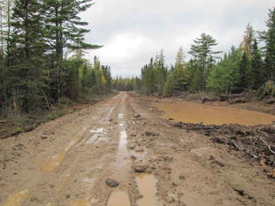 Water ponding on one side of the road can indicate interruption of the natural landscape hydrology. The construction of resource roads that pass through wetlands (such as fens
Print this page