New Gear
Harvesting
New Gear
Delair unveils drone solution for large-scale surveying in forestry
February 21, 2019 By Delair
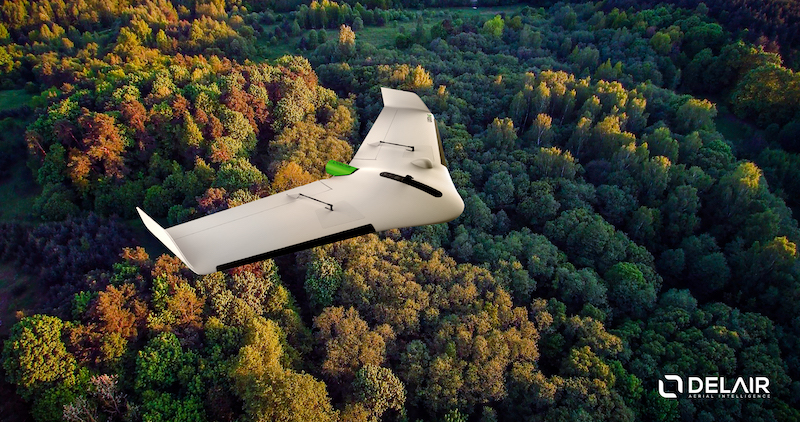
Delair, a leading supplier of commercial drone solutions, today announced the commercial availability of Delair Ag, a comprehensive drone solution specifically designed for agriculture and forestry. Built around the Delair UX11 Ag, a new fixed-wing drone optimized for the agriculture industry, and Delair Aerial Intelligence (delair.ai), industry’s most powerful aerial intelligence platform, Delair Ag provides a complete, integrated and easy-to-use workflow to collect, manage, analyze and share agriculture data.
Developed for agricultural companies, service providers, and researchers, Delair Ag unlocks the value of drone-based data, whether it is for crop health monitoring, field experimentation analysis, automatic machine guidance, precision ag practices or better crop traceability.
“The Delair UX11 Ag combines the productivity benefits of long-range/BVLOS flight operations with highly accurate survey-grade mapping and plant data collection capabilities, while the Delair Aerial Intelligence platform enables a new level of precision agriculture and helps maximize the quality of crops and yields,” said Lénaïc Grignard, product manager for the agriculture & forestry offer at Delair.
“The delair.ai platform offers a simple and powerful solution to process the aerial images collected by drones. The Ag-dedicated algorithms have automatically generated online and sharable maps and data from images captured in the field. The solution contributes to help Michelin improve the sustainable management of natural rubber throughout the value chain,” said Gregory Lesturgez, agronomist at the Michelin Plantation Department.
Advanced features of the Delair UX11 Ag drone
The Delair UX11-Ag fixed-wing drone, designed for BVLOS flights, reduces the amount of time and money required to provide detailed surveys of large-scale agriculture operations. With a flight time of up to 52 minutes, the Delair UAV typically covers up to 150 hectares per flight (or up to 30 hectares in 10 minutes) at 150m (400 ft).
Its precise automatic geolocation – PPK as you go – and wide area imaging technology further decrease its operational cost, which can be as low as €0.7/hectare. In addition, its ease of use makes it faster to set up and deploy, and an “ag-proof’ design lowers maintenance costs. Once airborne, real time monitoring and 3G/4G cellular connectivity gives pilots flexibility to adjust flights and camera settings, as well as see and verify results as they are collected to ensure the highest quality images are obtained. As a result, its ROI is extremely high, enabling the customer to see a payback in as a little as a few flights.
The Delair UX11-Ag features the MicaSense RedEdge MX, a fully integrated high-grade multispectral camera to see the plant level of most crops and provide the industry’s best quality agriculture data. The sensor generates plant health indexes and RGB (colour) images and is calibrated for precise, repeatable measurements.
The new drone is an easy-to-assemble and easy-to-carry system, weighing in at just 1.6 kg. Its dimensions and take-off capabilities make hand launching possible. The UAV features BTOL (bird-like take-off and landing) for steep-climb take offs and descents in confined areas, reducing down time between flights and extending its use to challenging environments such as dense vegetation in plantations or forests.
Industry-optimized analytics for greater efficiency on delair.ai
Delair Aerial Intelligence (delair.ai) is the industry’s most comprehensive platform for converting drone-based images into actionable business insights. The new cloud-based solution provides a complete integrated and easy-to-use workflow to manage, analyze and share data, streamlining the process for unlocking the true potential of aerial surveying. Industry-optimized analytics for specific industries and use cases in mining, quarries, construction, power & utilities and agriculture enable more accuracy and precision to deliver bottom-line benefits to a wide range of businesses.
Delair.ai offers agriculture and forestry specific analytics to digitize and better analyze crops, including:
- Crop mapping and visual scouting: Field visualization tools such as annotable and shareable 2D and 3D models, orthomosaics, geo-referenced and indexed maps, crop vigor, chlorophyll content, green biomass, etc.
- Inventories of fields or micro-plots: field boundaries, micro-plot vectorization, field rows, gap detection, plant counting, plant height and other plant characteristics
- Precision farming: automation of drone-to-machine operations, faster and more targeted responses to weeds, diseases and pests.
- Traceability of crops: follow more precisely and demonstrate what is happening exactly in the field.
Optimized for a seamless integration with the Delair UX11 Ag, Delair Aerial Intelligence is drone-agnostic and compatible with popular mapping software.
Print this page